History of what’s happened
Currently proposed Irish offshore wind farms are sited in environmentally inappropriate locations. Because site selection for offshore wind has been entirely developer-led, a number of massive projects have been proposed and shaped by private interests without any site-selection oversight, public consultation or environmental constraints. Developers have been allowed to exploit outdated, inadequate legislation and, in the absence of eco-system based Marine Spatial Planning, have picked out sites on ‘a first come first served’ basis based on potential profitability, regardless of the site’s ecological value. This undemocratic process has had active support from successive governments, with moves to a plan-led regime only initiated in 2023.
Sites chosen by developers are located on shallow, near-shore sandbanks and mudflats, adjacent to SACs and SPAs, and in other high biodiversity value locations. These areas are vital for breeding sea birds, spawning fish and as feeding grounds for whales and dolphins. The sea floor in many of the selected areas hosts valuable biogenic reefs and is home to a wide variety of marine life and vital for carbon capture.
Offshore wind farms represent massive and unprecedented industrial development at sea. Careful siting is internationally accepted as critically important if they are not to endanger the very environment they are intended to protect.
Location, Location, Location
Site Selection is internationally recognised as the most important factor in avoiding environmental damage.
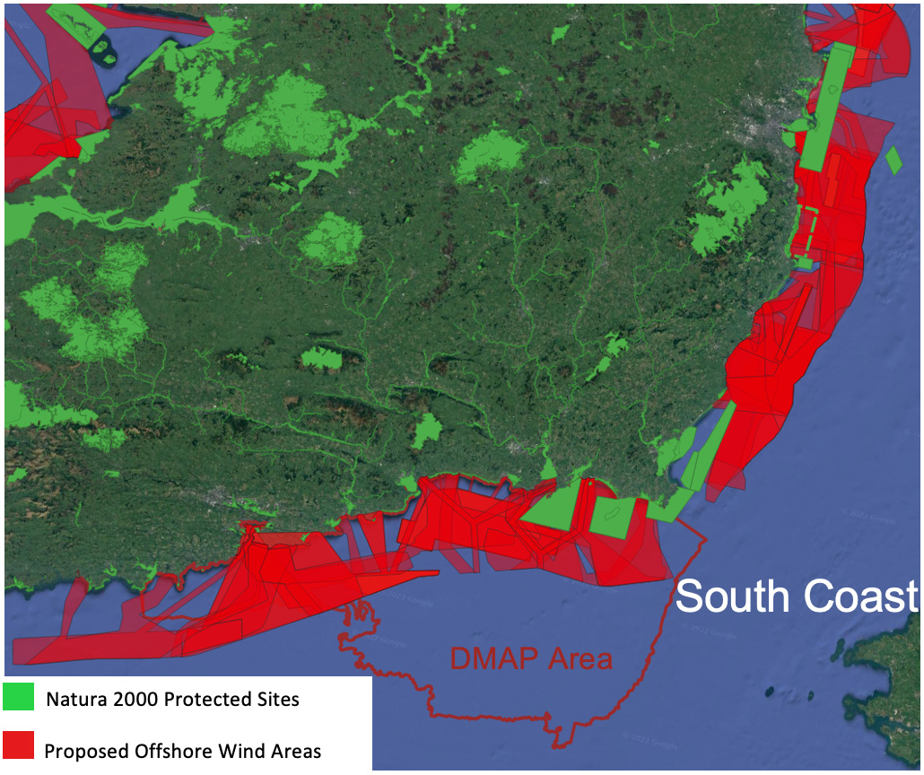
All proposed wind farm sites intersect with or are in proximity to Natura 2000 sites.
The most unsuitable sites possible have been targeted.


Environmental Impact Assessments
No Marine Spatial Planning
No Strategic Environmental Assessment
No cumulative impact assessment
No Appropriate Assessment to assess likely impacts on Natura 2000 sites
Environmental Impact Assessments undertaken by developers
Not impartial, objective, independent
Regulatory Inadequacies
No Natura 2000 site-specific conservation objectives; no adequate management measures
NPWS lacks capacity to oversee marine development (Review of NPWS, 2021)
An Bord Pleanála does not have expertise or capacity to deal with the complex issues arising from these development proposals
Ecologically Rich Habitats
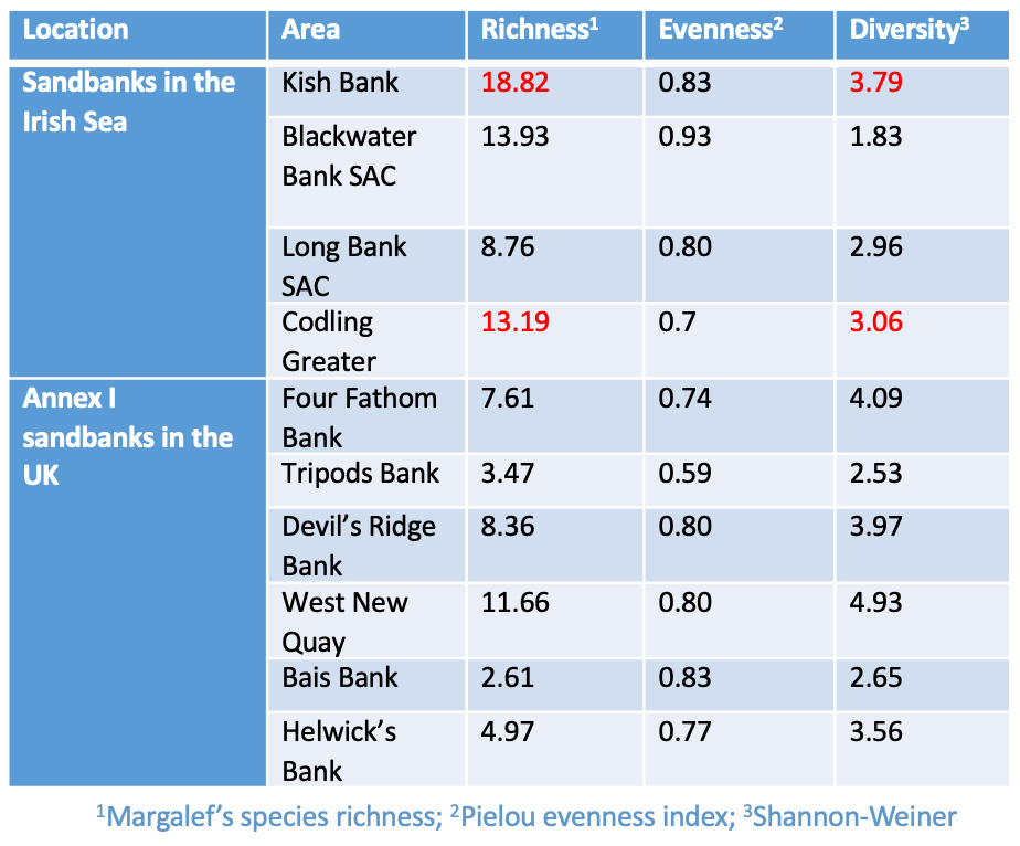
East coast sandbanks are Annex 1 habitats suitable for designation under the Habitats Directive. Ireland is deficient in Natura 2000 designations for this habitat type.
Shannon-Weiner Diversity Index measures species richness, evenness & diversity and is rarely > 4. The table gives values for east coast sandbanks, showing then to be very rich, biodiverse habitats.
Shallow-light filled waters and tidal stratification in the Irish Sea create conditions suitable for high concentrations of phytoplankton & zooplankton, which, in turn, support these rich ecosystems.
Rich Areas of Phytoplankton


Fair Seas Suggested MPA Sites
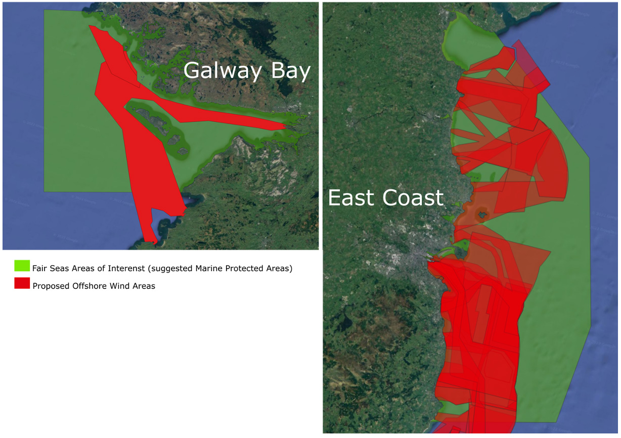
Fair Seas ‘Revitalising Our Seas’ selected areas suitable for designation as Marine Protected Areas (MPAs)
European target is for 30% MPA coverage by 2030
Using available data sets, their scientific approach identified areas based on overall ecological value
‘Phase one’ ORE proposed sites, granted Maritime Area Consents (23 Dec 2022), almost all lie within the areas assessed as suitable for MPA designation. As indicated on the map, this is also the case for the south coast Designated Maritime Area Plan (DMAP).
‘Phase one’ ORE developments that have been subject to no Strategic Environmental Assessment to comply with the EU Directive, almost all lie within the areas designated by Fair Seas as suitable for MPA designation
Bird Habitats – East
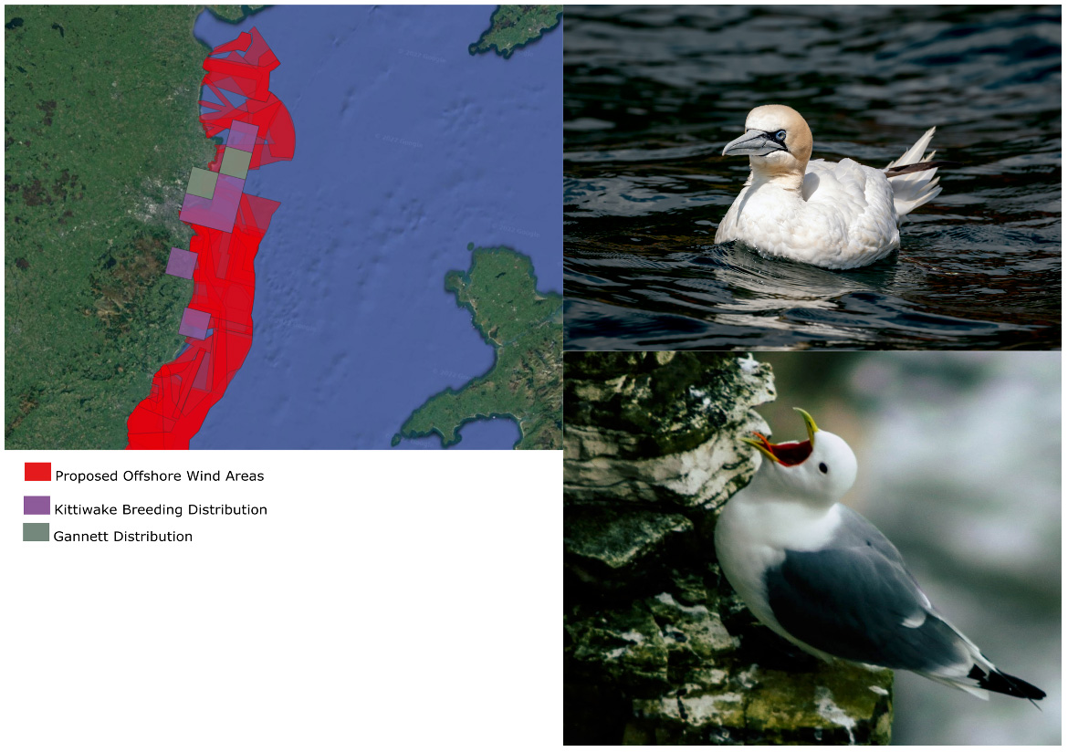
East coast sandbanks are prime foraging areas for endangered seabirds
Phytoplankton supports the proliferation of sand eel and sprat, the sole food of kittiwakes during the breeding season
Based on ecological value, early surveys concluded that they were unsuitable sites for development.
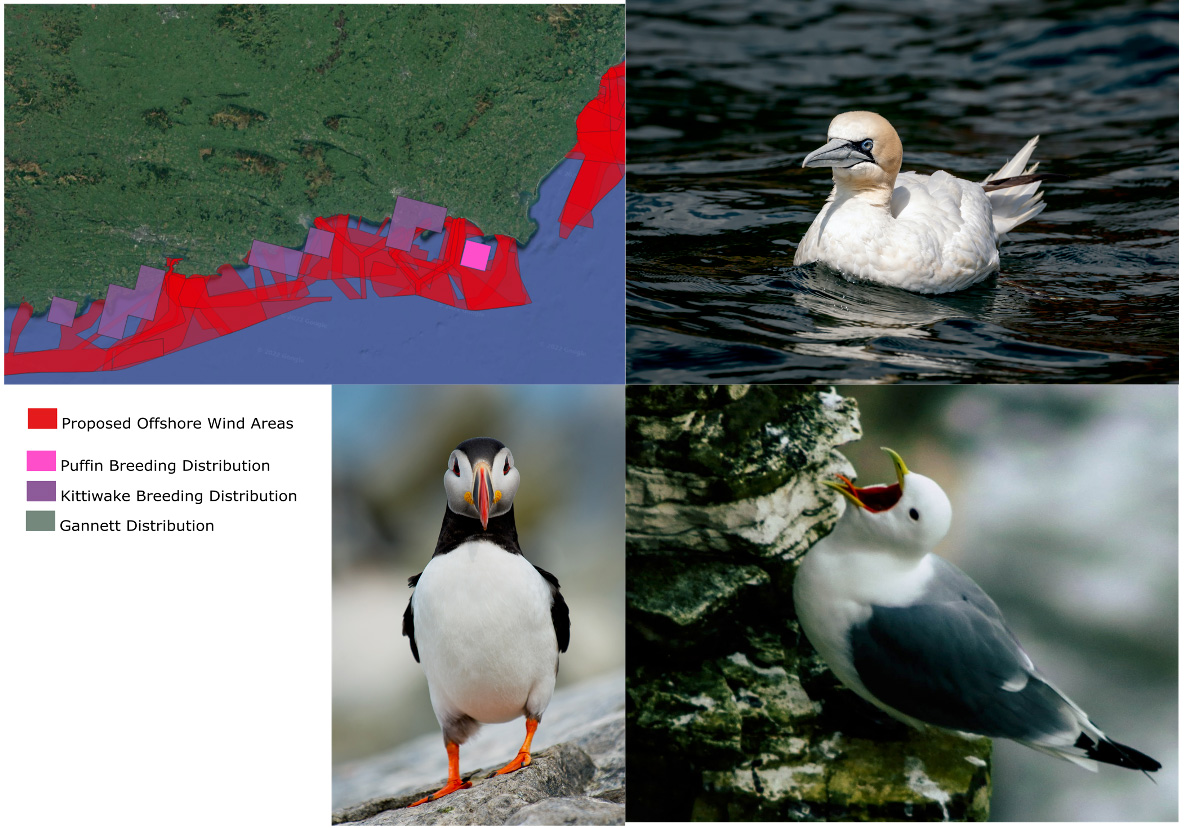
Bird Habitats – West
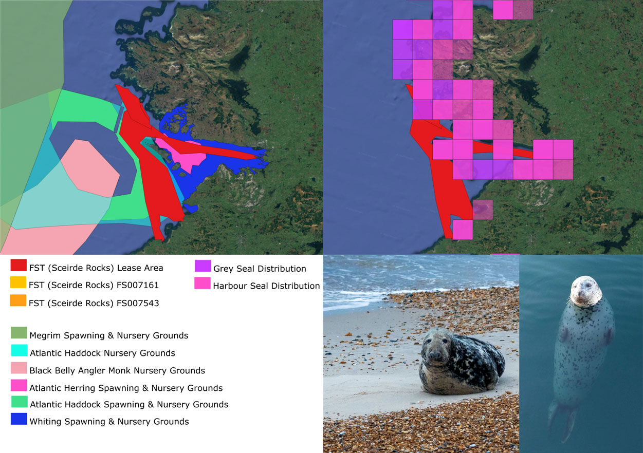
Sceirde rocks FST proposed wind farm site in Galway Bay is surrounded by Natura 2000 sites
This area is rich in sand eel and sprat, the sole food of kittiwakes and puffins during the breeding season
South Coast proposed wind farm sites are surrounded by Natura 2000 sites
This area is rich in sand eel and sprat, the sole food of kittiwakes and puffins during the breeding season
Seal Habitats
Grey and Harbour seal colonies are widely distributed around the FST site and on Ireland’s east coast
Populations are located in rich fish spawning and nursery grounds
Such habitats are vital for survival of endangered seal species.
Fish Spawning Grounds
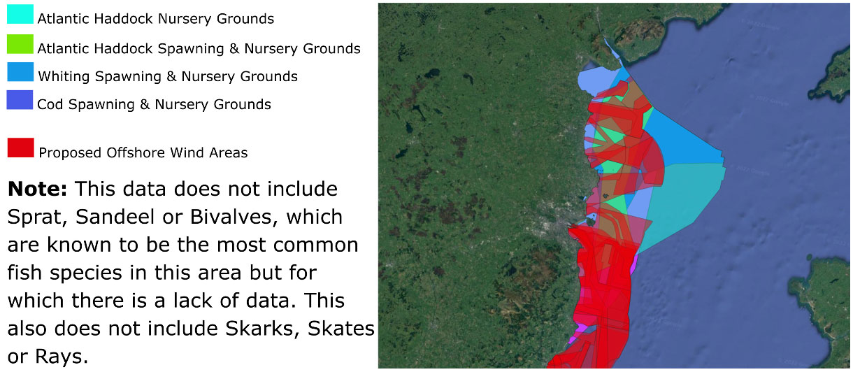
East coast sandbanks act as spawning and nursery grounds for fish species
They support numerous reefs and endangered species, such as rare & threatened Horse Mussel, reported by NPWS to be ‘functionally extinct’ some years ago, but now known to be actively reproducing here
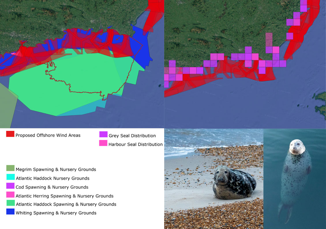
South coast areas act as spawning and nursery grounds for fish species
They support large numbers of grey and harbour seals.
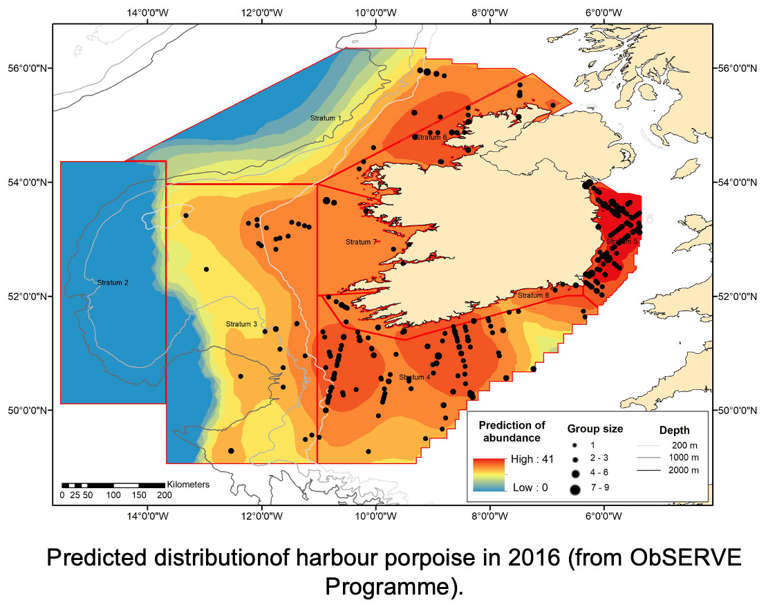
Harbour Porpoise Impacts
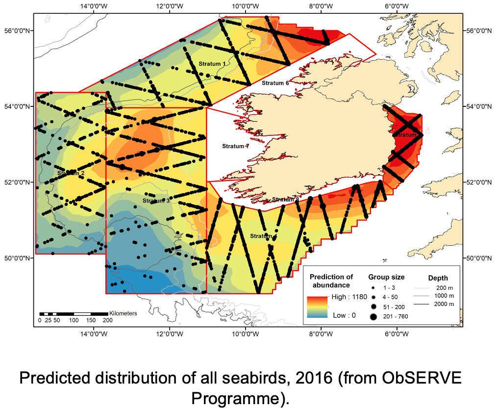
The ObSERVE programme conducted aerial surveys to investigate the occurrence, distribution and abundance of key marine species, with an emphasis on seabirds and marine mammals, in Ireland’s Exclusive Economic Zone, an area of > 420,000 square kilometres.
Birds Impacts
Distribution of all seabirds taken from ObSERVE 2016 survey results
Note the significant variation in distribution across Ireland’s EEZ.
Birds – Tern Impacts
The ObSERVE programme conducted aerial surveys to investigate the occurrence, distribution and abundance of key marine species, with an emphasis on seabirds and marine mammals, in Ireland’s Exclusive Economic Zone, an area of > 420,000 square kilometres.


Birds – Auk Impacts
Predicted density distribution of auk species (Razorbills, Common Guillemots and Atlantic puffins)
All of these auks are on the list of threatened bird species, with Atlantic puffins at risk of extinction.
Background Noise
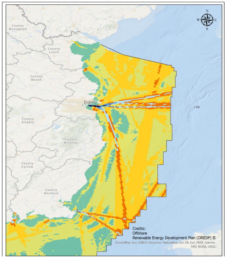
Extract from OREDP II
Green areas with low shipping density overlay the sandbanks
These are areas where hearing sensitive species (e.g. Harbour Porpoise) can get away from shipping noise, rest and feed.


Carbon Sequestration
High potential for carbon sequestration in areas targeted for North Irish Sea Array & Oriel wind farms and others
No assessment of carbon sequestration loss in environmental impact assessments.
References
1. Codling Wind Park, Ltd. ‘Investigative Foreshore License Application (Offshore Renewable Energy) April 2020. FS007045.
Available here
2. Codling Wind Park II, Ltd. ‘Application for foreshore lease to construct an offshore electricity generation station’ March 2009.
Available here
3. Codling Wind Park Foreshore Investigation License Application – Supplementary Information April 2000. FS007045.
Available here
4. ‘Habitat Directive’, Council Directive 92/43/EEC.
Available here
5. ‘Environmental Impact Statement in support of an Application for a Foreshore Lease to construct an Offshore Wind Farm under the Foreshore Acts 1933 to 1998 at Codling Bank’ Volume 1 & 3, Produced by Natural Power for Codling Wind Park, Ltd. 2002.
6. AQUAFACT International Services Ltd On behalf of The National Parks & Wildlife Service, ‘Subtidal Benthic Investigations of the Greater Codling Bank’, JN1157, October 2012.
